Friday, July 29, 2011

Forgettable War, Unforgettable Fort


Inside Fort Meigs looking at a southwestern blockhouse
Who knew that Ohio boasts the largest historic fort site from the War of 1812?  For that matter, how many even remember there was a War of 1812? Lost among the shuffle of wars taught in the classroom history books, the War of 1812 often comes up short or even missing. But just outside Toledo, Ohio on the inland banks of the Maumee River stands Fort Meigs, an impressive structure that repelled not once, but twice the British invasion of northwestern Ohio.

The War of 1812 isn't as easy to understand as the Revolutionary War or the Civil War,  where causes seemed clear and a war inevitable. President James Madison in many ways was goaded into action from war-mongering politicians, who were tagged with the first use of the term warhawk, over issues involving British practices at sea and out west in the Great Lakes region. Throughout the nation a sizeable number of Madison High Schools today tout the Warhawks as their mascots.

Historic Marker and Visitor Center at Fort Meigs
For Ohio the War of 1812 was about Indians and Canadians, as both were immediate threats to the barely decade-old state. Fort Meigs was built to protect the interior of Ohio from coalition of English and French. The fort stands on the footprint of the original fort and features a nicely sized museum and visitor center. Built in 2003 as part of Ohio's Bicentennial celebrations, the winding displays give a great sense of the timing of the war and the artifacts of the time and those found at the site. A corner of the museum shows how modern science, including thermal imaging was used in renovating the fort.

Costumed interpreter reacting to musket demonstration
A visit on the right day might begin with a tour of the musuem by a costumed interpreter. On this visit the interpreter, a college-aged girl, remarked that in the 19th Century she did not have the right serve her country as a soldier but in the 21st Century does, including re-enacting one.

Fort McHenry in Baltimore certainly gains all the publicity and attention for the War of 1812, having been the site where Francis Scott Key penned the words to the Star Spangled Banner and what would later become the National Anthem.  But Fort Meigs is supersized in comparison to her east coast companion's star shaped designed.  Meigs is spread out over what could encompass two to three city blocks, with sturdy blockhouses every several hundred feet.

One of the eight blockhouse of Fort Meigs
These blockhouses not only served to repel Indian and British forces during the two sieges between May and July of 1813, but later housed pioneer families coming to northwest Ohio while their own homes were built.  Lore has it that one family, late in arriving and unable to secure housing in a blockhouse, set fire to the blockhouse.

Canon portal inside ground floor of a western blockhouse
The walls of these structures are several feet of solid wood with rifle portals that angle inward, giving a small outward target but inside the blockhouse a wide angle to swivel a gun for better accuracy.  A small cannon rests in the middle of the main floor room of each blockhouse with a narrow opening for firing outward.  Today the opening masks the intended view as tall grass obscures a view towards the river.
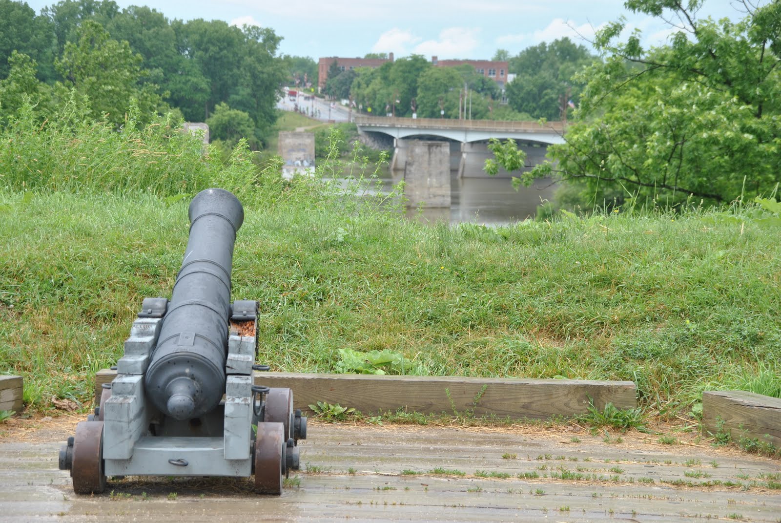
Croghan's Battery overlooking the Maumee and Perrsyburg
Each of the blockhouses today houses a different story about the fort, from soldiers quarters, disease and the role of women, to the science of artillery and a diorama of the fort's early construction. Artillery is a large part of the fort's story, defense and modern re-enactments. Each July 4th costumed interpreters hold a grand series of events, including a cannon fire demonstration on the grounds (click for video).

A series of large mounds were built within the interior of the fort to serve as buffers to artillery attacks from outside the walls and to also for fort storage, including powder magazines.  In 1908 a 100-foot monument to the war and the fort was erected, funded by the Grand Army of the Republic (a Civil War veteran's organization).


WPA Shelter House seen through blockhouse window

After the war and settlement of the area progressed, the fort reverted to farmland.  William Henry Harrison, hero of the war in the region, returned to the location of the fort for a Presidental campaign rally.  During the Great Depression, a road ran right through the former fort and the Works Progress Administration (WPA) built a rest-stop building inside what is today the fort.  The building has been maintained for its historic nature but for a different era.

The fort was reconstructed by the Ohio Historical Society in the 1960s and opened to the public in the 1970s.  A $6 million renovation in 2003 has turned the fort into the largest recreated fort in the nation, something that, just like the War of 1812, tends to get overlooked still today.

Fort Meigs, from the interactive displays, visitor center, museum and carefully reconstructed fort, offers a glimpse into a part of Ohio's history that featured dynamic individuals, such as Tecumseh and Harrison, and, of course, a naval battle on Lake Erie where Oliver Hazard Perry famously noted, "We have met the enemy and they are ours."  

J.


View Larger Map

Wednesday, July 6, 2011

A diverse and "beautiful spring" in Tuscarawas County

One of Ohio's first settlements was a diverse little village nestled in what is today on the outskirts of New Philadelphia in Tuscarawas County.  Schoenbrunn Village was a Moravian settlement, dating from 1772, that brought religion to the natives of Ohio.  Led by David Zeisberger, natives, primarily Delaware, were asked to abandon their traditional way of life to take up a Christian lifestyle in the village.  By all accounts the settlement enjoyed success in its mission and at its greatest had over 400 living within its walls that included natives from nine tribes, with the majority being Delaware. 

Interior of a larger home at Schoenbrunn
Originally from what is today the Czech Republic, Moravians named this village "Beautiful Spring" in German. The settlement, with a grand total of 28 men, women, children and a herd of cattle, moved to Ohio from northeast Pennsylvania where the Moravians and Delaware had spiritually worked together since 1734.  The location was chosen by a Delaware Chief, Netawates, or in English, Newcomer.  Just 20 miles from New Philadelphia lies the Ohio town, Newcomerstown, which English traders named in honor of the chief and had over 100 homes in the area by the 1770s. The Delaware called the Schoenbrunn location "Welhik T'uppek."

The Moravians, however, were pacifists and in the mid 1770s the Revolutionary War was reaching even into the Ohio territory.  Ft. Laurens, in what is today Bolivar, Ohio, was built in 1778 and the western theater of the war saw fighting in the northeastern Ohio territory.

Living somewhat apolitically in a self-sufficient community of Delaware and former Europeans, there was distrust by other settlers in the area whether the village was patriot or loyalist.  By 1778 the village was abandoned, but not before the church was taken apart to prevent desecration by others.  The village was reoccupied later that year, but only briefly as war continued to threaten the region.

The property in the early 1800s reverted to what much of Ohio had become: farmland.  Over 150 years later a minister of the Moravian Church, which still exists today, began researching the "lost" village.  Church records in Bethlehem, Pa., showed plat maps and journals by Zeisberger of the village's five-year run.  In 1923 the Ohio Historical Society took ownership and began to reconstruct the village.

A period interpreter stands outside a home at Schoenbrunn
The Visitor's Center at the site hosts a small, two-room museum displaying artifacts from archaeological digs. A conference room in the center doubles as a type of theater which loops a video of the construction of the village by the Ohio Historical Society.  Pictures along the walls show various stages of construction of the village, including an unusual aerial photo from 1930s that show how the land looked very different in the mid 1900s.  At the time of the dedication of the first re-constructed building, cars were parked haphazardly all over the farmer's field.  Today forest has grown around the village, restoring much of the look of the original village.

The school house glass window reflects more of the village
Of the 60 structures in the original village, today only 17 have been reconstructed.  Some of the buildings have been built upon the original foundation footprint from the 1770's. Moravian villages were spiritually laid out in the pattern of a cross, although the landscape at Schoenbrunn only allowed for a "T" pattern.  Anchoring the intersection of the two lines are the church and schoolhouse, both impressive structures.  Both contain glass windows, a rarity for frontier Ohio.  Records show glass was brought to the village and even today the wavy look of leaded glass adds authenticity to the recreated structures.

The schoolhouse, where period interpreters today will sometimes teach visitors Lenape, the Delaware language, was the first established school in Ohio.  However this is done in two "choirs" -- these were youngsters of the same age, gender and marital status.  Girls sat on one side of the room, boys on the other.

A period interpreter working on wooden hinges. 
The schoolhouse is the building in the background.
A visit to the village today on a weekend or special events day will yield period-costumed interpreters who will share the wares of the time. In one home a lady shared contemporary devices and their 1770s counterparts.  A woodworker along the main village way was constructing wooden hinges -- metal was another rare commodity in the woods of Ohio at the time. On a Children's Day, a colonial magic show kept little ones spellbound while a few houses down kids played colonial era games.

Schoenbrunn Villages fencing
Schoenbrunn also boasts a unique fortified fence, where poles, about 12 inches in diameter, were driven into the ground and seemingly stands at odds with a people of a pacifist nature.  It is only along the main avenue of the village.  Oustside the fence is the corn field, where children would alternate taking turns shooing away the wildlife. Corn was essential to the village and outside one home stands what could best be described as a colonial corn kerneler.  The raised notches in the drum would strip the niblets off the cob.
A colonial corn kerneler

As with many historical sites around Ohio, Schoenbrunn fell on hard times as state monies were diverted elsewhere.  The originally re-created village was renovated in the past decade to address decay that had crept in to the buildings.
Period interpreters, even the young ones, like to play

Today Schoenbrunn has undergone yet another re-birth and is being operated locally by the Dennison Railroad Depot. Throughout the year there are events such as a colonial trade fair, lantern tours and children's day.  All of these offer very unique and hands-on history and have added to the allure of stepping back into time to before Ohio's birth as a state when diversity was practiced long before its time.


- J.


View Larger Map

Sunday, September 5, 2010

Marietta: if only

Campus Martius Museum (click to enlarge)
They say that it's all about location, location, location.  Marietta, Ohio, has that down.  Or so you would think.  Nestled between the Ohio and Muskingum Rivers,  Marietta (map, wiki) is at a junction that was historically significant with implications for future greatness.  If only... history had chartered a different course.

Model of original stockade inside
footprint of Rufus Putnam House
(click to enlarge)
In 1788, George Washington's friend Rufus Putnam led 48 men of the Ohio Company Associates to Ohio to begin surveying and settling lands in the Northwest Territory formed out of the Northwest Ordinance of 1787.  They named the fort built at the confluence of the Muskingum and Ohio Rivers Campus Martius and from here Ohio grew with the influx of New Englanders and later Virginians and Kentuckians.  Today Campus Martius is a museum of the same name on the same ground of that first stockade.

Left is original home, right the
reconstructed (click to enlarge)
Originally settlers had a home inside the stockade walls, which were never attacked by natives, and a plot of land on the outskirts of town (where natives were known to attack).  Rufus Putnam's original house is uniquely housed in the museum. 

Original Putnam home
(click to enlarge)
Weather and insects began to detoriate the structure and when the house shifted several feet while visitors were present it was time to preserve and reconstruct.  The museum was built over and around the original structure.  Some of the original house has been saved but much of the frame has been reconstructed next to the original and the items moved inside the newer built structure. 

Conestoga wagon (click to enlarge)
The museum has three levels of exhibits, with the first level showcasing the time around the 1800's when Marietta was the entry point for many settlers into southern Ohio and the hub of surveying the Ohio territory.  The main lobby has a Conestoga wagon packed with exemplary items for a journey to Ohio. The second level, a balcony overlooking the lobby, has many artifacts from Marietta history beyond its roots in the 1790s.  The lower level displays a broader history of Marietta, focusing on its place as a transportation conduit and the natural resources found in the Ohio River Valley.

original Campus Martius well (click to enlarge)
The museum is part of the Ohio Historical Society and is two museums separated by a long block.  The second museum is the Ohio River Museum located on the Muskingum River just west of Campus Martius.  Walking south from Campus Martius, one can pass the old public well that was used originally in the stockade and then was a public work for nearly another century.

1891 marker of Campus Martius
(click to enlarge)
Continue south, then around the block walking west of Campus Martius takes one past homes that are a bit outdated and in need of a little attention, bypassed by a bridge that takes the main road across the Muskingum River.  But walking this route takes a visitor right by one of Ohio's earliest historical markers noting in 1891 the location of the original Campus Martius stockade.  Ivy has grown around and partially over the marker and it is easy to miss if one is not looking for it.

Flood markings at Ohio
River Museum (click to enlarge)
The Ohio River Museum serves many purposes along its riverfront property.  There are about a half-dozen state historical markers from many different eras in history, from colonial settlement to the Underground Railroad.  The main museum is elevated on posts, a nod to the power of the rivers to flood the area.  Several telephone poles have been sunk on the property at heights that denote the level of floods over the past 200 years -- a very vivid reminder of the dangers that "location, location, location" can bring. 

replica flatboat (click to enlarge)
Scattered below the main building and around the property are different boats of historical nature.  A steamboat pilot house and a full-scale replica of a flatboat show two different ways of navigating the rivers.  The flatboat, a cheap and unpowered source for rafting your family and possessions down the river, is akin to a low-slung cottage house that floats.  The pilot house displays an architectural style unique to American history and iconic of the steamboat era.

Large scale steamboat model
(click to enlarge)
This museum is not a particularly large museum and if the only museum in town not worth the visit.  But partnered with Campus Martius, the two together make for a good visit.  Greeting the visitor inside the main building of the Ohio River Museum is a large-scale model of a riverboat, approximately 20 feet long with a picture of the builder sitting on it as it floats in the river. 

Steamboat artifacts (click to enlarge)
The model provides a great insight to the river's place as a transportation and commerce avenue for the midwest.  Two other buildings are separated by covered walkways and have artifacts from the era of the steamboat, including a two-story pilot's wheel.

At the junction of two rivers, with one that directly links the east to New Orleans and the Gulf of Mexico, Marietta had the opportunity to become the queen city of the midwest.   But much like how a river runs its course in unpredictable ways, Marietta was soon to be bypassed by political and technological circumstances.  Territorial Governor Arthur St. Clair had a plan for dividing the Northwest Territory that would have been favorable to the long-term growth of Marietta.  But his plan was not adopted. 

By the 1830s, Ohio's government had built canals connecting Lake Erie to the Ohio River -- but west of Marietta at Portsmouth.  By the mid 1850s the railroad too had transversed Ohio but well north of Marietta.  Today Marietta is essentially bypassed yet again, as I-77 moves travelers over the Ohio River at the eastern edge of the town several miles from the downtown area.

view from top of Mound
Cemetery (click to enlarge)
Marietta never managed to become the size of Cincinnati at its peak but still today enjoys a better situation than many southeast Ohio towns.  The history, tourism and recreation of the area has allowed it to stay somewhat afloat compared to the region.  Barely 2,000 people inhabited Marietta by 1840 (contrasting with Cincinnati being the largest city west of the Appalachians at the same time at 46,000), rising to about 5,000 after the Civil War and the 2000 Census claiming just under 15,000.

The town had the foresight to leave many of the ancient Indian mounds that predated white settlers, with the main mound not far from Campus Martius becoming Mound Cemetery.  Buried side by side and spanning several hundred years, are natives and settlers, notable early Ohioans and Revolutionary War veterans.

The downtown area of Marietta works hard to maintain viability with events throughout the year. There are several nice restaurants in the central business district, with some being in  historic properties.  The Lafayette Hotel harkens from 1918 as one of the last riverboat hotels along the river.

Historic Marietta property
(click to enlarge)
At one time the Becky Thatcher Steamboat served as a docked restuarant and dinner theater, but went out of business due to flooding and low interest in the 1980s, was towed to Pittsburg in 2009 and subsequently sank in February of 2010.  But each fall there is a sternwheeler festival in town that draws thousands to the riverfront in what is billed as the "granddaddy" of the sternwheeler gatherings. 

And so goes Marietta, a town that continues to fight the currents of history and economics. Such are the ebbing and flowing of a town that started Ohio on the road to prominence and still today beckons to remind us of how we got started and how we moved on.

-J.

Sunday, August 22, 2010

A corner on the market in Dayton, patent pending of course!

Dayton, Ohio sits along I-75 a short hour's drive north of Cincinnati. While noted for the Wright Brothers and Paul Laurence Dunbar, Dayton at one point was the center of the nation when it came to technology and design. Today the Dayton Aviation Heritage National Historical Park (see right, click to enlarge) lets you step back in time on a corner where the spirit of innovation not just soared, but was started, inked and cashed too.

The Dayton Aviation Heritage National Historical (web, map) lies about one mile west of downtown, and encompasses the historic Wright Brothers Cycle Complex building, the Wright-Dunbar Interpretive Center and the Aviation Trail Visitor Center & Musesum, at the corners of W. 3rd & S. Williams St. in Dayton (see left, click to enlarge). The park is dedicated primarily to the Wright Brothers with a healthy dose of Dunbar added, but there are other elements of Dayton's legacy included in the museum.

An replicated building that housed the fifth Wright Brothers Cycle Company (see left, click to enlarge) serves as a museum piece, and includes many displays of recreated bicycles produced by the Wright Brothers, including the legendary Van Cleve series (see below-right, click to enlarge). The Wright Brothers did not make bicycles, but rather assembled what they felt were the best pieces to form their own creations. Sadly no originals are left to display at the museum. The rear of the building shows a recreated workshop, where their flight engineering developed in their spare time. Henry Ford purchased, dissambled and re-assembled the original cycle shop and house that was a few blocks away at his Greenfield Village museum complex in Detroit.

A short walk across a nicely designed plaza places a visitor at the entrance of the Aviation Trail Visitor Center and Museum. This entrance was built onto the existing and renovated structure that originally housed the Wright Brother's second story print shop and the family's ground level general store. Design elements entice the visitor with enticing architecture and massive graphics of the Wrights and Dunbar (see right, click to enlarge).

An oversize billboard on the building southern facing wall graces the plaza (see right, click to enlarge) and was reproduced from a local newspaper touting the brothers' return in the early 1900's from a European business trip. The Wrights were manipulative entrepreneurs and after successfully mastering powered flight, shut down their test flights to keep their designs private. They then embarked on visits to here and abroad looking to sell their designs for military use. Dayton threw a massive celebration upon return home after one of these junkets.

The two-story museum is unique in that several rooms are recreated as they were a century ago. The general store is laid out in one room as it was then. Lost to the casual visitor is a fanciful and antique cash register amid the shelves of goods (see right, click to enlarge). It was in Dayton where the cash register was born and improved, first by James Ritty and John Birch in 1883, then by John Patterson later, who founded the National Cash Register company -- today known simply as NCR.

Unknown to many, Dayton had, and still claims to have, more patents per capita than any other place on the planet. There are over 100 patents laying claim to Dayton, Ohio on file with the government. Charles Kettering added power components to the cash register, but later is better known for letting the ladies get a chance behind the wheel of the horseless carriage. It was Kettering's idea to add an electric starter to an automobile, removing the labor-intensive hand-cranking to start the engine.

Between the Wrights and Kettering, these Dayton men engendered a gender revolution. Bicycles and automobiles allowed the ladies to move about as well, and bicycle trends signaled a change in fashion trends for long skirts and bicycles are not compatible. Bloomers became a new fashion style for Victorian ladies.

While Paul Laurence Dunbar's contribution to history lay principally in his poetry and literature, his connection to the Wright Brothers is sometimes also lost to history. Unfortunately young people tend to learn history in compartmentalized themes and authors and poets do not typically show up in the same chapter as technological advancements at the same time. Friends through attending classes at Dayton Central High, the Wright Brothers second floor print shop was where Dunbar self-published his own newspaper, The Tattler (see right, click to enlarge). Oddly the University of Dayton's Dunbar website is silent on the relationship between he and the Wrights.


Orrville and Paul had become best friends and shared political similar political ideals. One of the second floor rooms is devoted solely to Dunbar. The remainder of the second floor museum pays homage to the timeline of flight, including a nice display where one do a photo-op appearing as though parachuting from the sky.

A small theater on the ground floor runs a 30-minute biography on the Wright Brothers that tells more of the story of powered flight than people tend to know. Another flaw in the teaching of history is that when an accomplishment is reached and shared, the story ends in favor of the next event in history. There was much more to the Wright's story following Kittyhawk's first flight and it was centered in Dayton.

The final element to the park is a good 20 minute drive northeast, and the location where the Wrights did their test flights of the powered Wright Flyer. Today Huffman Prairie Field is encircled by Wright-Patterson Air Force Base, but access to the historic landmark does not require entering the base. Bounded by a series of large white flags, as they were over 100 years ago, the field contains a recreated shed and catapult tower and track (see right, click to enlarge). The lack of an ocean breeze hindered getting their first planes airborn and the ingenuity of a catapult -- not far removed from how aircraft are launched from aircraft carriers today -- soon followed.

Dayton's place in history is rooted in flight, but it is the innovation of its citizens that literally -- and metaphorically -- cornered the market on technology.
J.

Thursday, August 5, 2010

Dishing the dirt... on coal in Guernsey County

You will be hard-pressed to gain a better understanding of the life of a coal miner than a 10-mile trek along the rails winding south and west through Guernsey County along the Byesville Scenic Railway (see right, click to enlarge). Just two miles south of the I-70 and I-77 interchange, Byesville is a stop along the Marietta & Pennsylvania Railroad and later the Baltimore & Ohio Railroad (B&O).

It is the combination of Ohio's earthen riches (coal) and transportation routes that make Guernsey County significant to history. Zane's Trace, a government funded trail in the late 1790s, was constructed to open up the lands of Ohio and Kentucky to the east, passed directly through the county. Zane's Trace became the National Road, and eventually U.S. 40, and further developed as an interstate (I-70) in the 1960s through the Eisenhower Interstate System. Just as the interstate system bisects the county, so do the rail lines moving significant amounts of cargo through Ohio to the Great Lakes and beyond.

The Byesville Scenic Railroad (BSR) offers a casual (about 12 mph) trip along the Marietta & Pittsburgh and B&O lines, beginning in its namesake, Byesville (see right, click to enlarge). The town's growth a hundred years ago was due to the high volume of coal workers in the area descending upon the city. Following the Civil War, coal mining became a huge endeavor in and around Byseville with dozens of mines being operated (see full history of Guernsey County). The city was incorporated in 1882 with a mere 300 people and today stands at 2,500 according to 2000 census totals. Between its incorporation and the height of the coal era, over 12,000 people (mostly coal miners in the region) are said to have visited town for shopping and entertainment.
The newly built station in Byesville (see left, click to enlarge) is the starting (and concluding) point for the rail excursion. Still being finished in the summer of 2010 were what appeared to be permanent offices, restrooms and souvenir shop. Here, passengers climb aboard one of several old rail cars, some originally built in 1918, nestled behind the purple and black diesel locomotive replete with logos of the BSR. Recently flooding severely damaged rails along the route, but despite this the BSR, certainly not immune to the modern economic difficulties of non-profit organizations, rebuilt the sections and operates normal tours and special excursions.

The cars (see left, click to enlarge) are spacious with ceilings that would be high for even modern luxurious homes. The windows, although aged, open and hold at different heights. It is recommended that passengers refrain from sticking anything out the window as the windows are heavy and dislodging from the set height could seriously hurt an appendage -- not to mention at several points objects along the railbed are very close (bridge trestles) or brush the cars (shrubs and branches). Looking at the details of the near century old passenger car one can find details of craftmanship that are noted on hinges, fasteners and latches (see right, click to enlarge).

The southern five mile route is a leisurely roll through gentle countryside but also economic hard times. From the windows can be seen sweeping hills, open wetlands and struggling local areas in another part of Ohio hard hit after industry has moved on. Through a wireless microphone and a speaker swaying dizzily from a mount on the car's ceiling mid-train, a narrator talks of the railroad, the landscape, the people of the area and a little about coal mining.

Some of the wetlands passed are more recent, as mother nature is reclaiming abandoned coal mines as collapsing roofs and mineshafts lead to natural flooding of the freshly created lowlands.

The area and people have seen tough times, and is evidenced by some of the sites seen outside the car's window. A few makeshift memorials are passed along the way for those who gave their lives in the grueling and dangerous occupation of coal mining (see left, click to enlarge). There is a movement by the BSR to construct a permanent memorial in Byesville that tributes coal miners.

Along the way the narrator jokes about the "local airport", where at one of the homes passed an old plane fuselage sits at the rear of the property either in storage or awaiting restoration. Another property showcases what looks like a 1950s gas station, with vintage pumps, building and signage -- and even the frame of an appropriate era car (see right, click to enlarge).
The train settles to a stop (see left, click to enlarge) about 8 miles from another Ohio tourist destination, The Wilds (web, previous blog entry). The wildlife preserve, operated by the Columbus Zoo, is located in Cumberland, Ohio and future plans (already under way) are to connect the BSR with the Wilds to give tourists a chance for a train ride on their visit to the preserve. The seats are here reversed in the cars (to keep a forward view of the activities) and the narrator undertakes a transformation.

The return trip, giving the tourist an alternative from much of the same vistas just encountered out the window, is an entirely different experience. The narrator applies some make-shift make-up to take on the look of a coal miner complete with tools (see left, click to enlarge). He enters into more of a first-person role and the following hour is time well spent back in history and deep underground. A little Johnny Cash provides the soundtrack at the beginning of Act II (as it were), as the strains of "owe my soul to the company store" (from Sixteen Tons, an often recorded folk song) set the tone for this trip back in time and back to Byseville.

Such personal interaction with the working conditions that were harsh (coal dust, trapped gases, flooding, etc.) to treatment that was less than ideal (payment of 10 cents a ton) and work that wasn't always constant (see right, click to enlarge) provides a stark contrast to the serene first half of the excursion. One learns of how the company store owned the worker, where payment (done in scrip) was redeemed only at that store and even homes were built on future scrip credit. All of the miners working tools, clothes, lunch pail, etc. were bought from his own pocket... and at the company store. As the narrator implies, it was essentially a form of slavery or indentured servitude.

It is a wonderful ride back in time, and the entire return trip feels like an authentic journey to a place a century ago where workers toiled long and hard, prying from thin and long veins in the earth the raw materials that would propel America into post-war Prosperity. Often overlooked is that many a men chose a different wartime path of patriotism by going into the mines to provide the literal fuel that would fire a nation's industry in wartime. The planned memorial seems all the more fitting upon arrival back in Byesville.

It's another of Ohio's intriguing place in history that can be found just minutes off the highway, along roads travelled hundreds of years by countless individuals.
- J.

Monday, August 2, 2010

A real pottery barn... and then some!

East Liverpool, Ohio, is an Ohio River city at the point where the river first defines the state's border with West Virginia and Pennsylvania (see map). Its population is just over 13,000 people (as of the 2000 Census) and a drive in and around town masks the national, if not international, importance the town played for an entire industry. The decaying buildings and factories struggle to find tenants and uses, but a century ago East Liverpool was the place to be if you wanted to succeed in ceramics (see right, click to enlarge).

Founded not long after Ohio was first
settled, East Liverpool's birth was in 1800 as the town of St. Clair until the 1830's and a transition to its modern name (more history here). An English potter, journeying from Pittsburgh to Cincinnati in 1840, stopped at East Liverpool and was impressed that the outlying land was rich with clay. He abandoned his journey at set up shop and soon the area swelled with potteries (see left, click to enlarge). By 1860 over 20 different companies had set up in town with the tell-tale conical brick kilns serving as a unique quasi-skyline along the river. Potteries continued to grow in numbers through the 1880s, where at one point in time over 50% of all pottery in the U.S. was being manufactured in East Liverpool.

The town was a thriving economic center and a sketched map (the Google Map of its day) showed a city stretching far and wide with little vacant land (1876 picture here). Overlooking the river, the (then) modern school was a large, three-story building with matching bell towers. Today the only remnants of that structure is a non-descript, single-story Board of Education building sitting in the footprint of the former school with one bell tower serving as a bridge between the past and present (see left, click to enlarge).

The former U.S. Post Office has been creatively turned into the the Museum of Ceramics (see right, click to enlarge), an Ohio Historical Society property managed locally by the Museum of Ceramics Foundation.
Originally opened in 1909, the post office featured ornately decorated domed ceilings (see left, click to enlarge) and a beautiful marble and terrazzo floor. In 1970 the post office moved across town and the State of Ohio purchased the building in anticipation of a museum that began later on-site in 1980.

The museum is a traditional museum (see left, click to enlarge), where there are many displays and dioramas, but there is little hands on for younger visitors. A small theater offers a short video on the growth of the pottery works in the region and the different types of pottery found on display in the museum.

The wide array of pottery showcased ranges from simple every day uses to luxury and elite works. There is a large sample of Lotus Ware on display, which is considered the finest porcelain made in the U.S. (see right, click to enlarge)

The first signs of decline in the industry came from the increase in indoor plumbing and bathrooms. The traditional washroom of a chamber pot, container and pitcher used for cleaning up were no longer the standard in most homes. By 1900 a large portion of clay was being brought into East Liverpool rather than dug locally, but the industry still flourished.

As with a lot of industry in Ohio, companies moved on to greener pastures by the mid 1900s and East Liverpool has since struggled to find economic success. The population topped out at 25,000 in 1950 and has steadily declined since. But proximity to both Pittsburgh (one hour)
and Cleveland (90 minutes) still place East Liverpool in a good location and there is still pottery manufacturing in town. While PNC bank may now operate in the centennial (1881) Potters Bank and Trust building (see left, click to enlarge), the library built by industrialist Andrew Carnegie (see right, click to enlarge) still operates 100 years later and appears ready to take on the next 100.

-J.